Landscapes
The Rural Landscape
Noto’s highest point is Mt Hodatsu at a height of 637m, situated at the base of the peninsula (summit is part of Hodatsushimizu Town). The rest of the peninsula is generally made up of hilly areas under 300m with no large alluvial plains, and it is typical to find terraced areas along the coastline. Marked differences are seen between the main part of the Peninsula on the Northern side (Diagram II – 7-1-I) and the Southern side of the peninsula (II in the diagram), with the dividing line at Ouchi Valley which extends from Hakui City in the Southern part of the peninsula to Nakanoto Town. The main part of the peninsula (I) is further divided into the Northeast section (Ia), the Northwest section (Ib), and the central section (Ic). In the Northeast section, high mountains are scattered across the northern side, and the northern mountainous area is further divided into two with the Machino River valley as the dividing point for the East side (Ia1) and the West side (Ia2). In the Northwest section (Ib), there are large flat areas at an altitude of approximately 300m.
The terrain of the Southern section of the peninsula (II) is mainly steep, and there are no elevated flat areas as seen in the main part of the peninsula (I). It is divided into the Northern section (IIa) with its highest point as Mt Isurugi at 565m (Nakanoto Town), and the Southern section (IIb) which includes Noto’s highest peak of Mt Hodatsu at 637m.
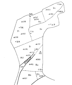
Diagram II 7-1: Geographical Divisions of Noto Peninsula and an overview of the main mountains
(Source: Yoshio Kaseno (1965), p3)
There are four large climatic divisions (Diagram II-7-2). Division I has features most typical for the Japan Sea side, and includes the band of Northern coastline, but due to the strength of the winds, it is further divided into the Winter Season Gale Area (Ia) and the Winter Season Wind Shadow Area (Ib). Division II is an area in which winds are calmer than Ib, and as a result of the difference in wind strength due to geography, it is further divided into two small areas IIa and IIb. Western Coast Division III is the most wind beaten side, being in the path of westerly winds. The Inland Division IV has a high level of rainfall and snowfall, and with low temperatures it is a climatic division quite different to the coastal areas (Diagram II-7-3).
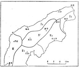
Diagram II-7-2: Noto temperature distribution (Source: Kichikawa / Yazawa (1955), p20)
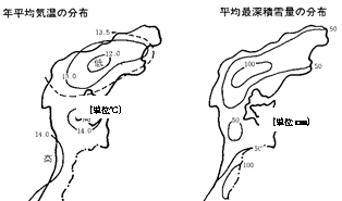
Diagram II-7-3: Noto Peninsula yearly average temperature distribution and distribution of average record snow depths (Source: Ishikawa Prefecture (1993), p6)
Yearly average temperature distribution
Unit: °C
Distribution of Average record snow depths
Unit: cm
With consideration for the geographical divisions and climatic divisions listed above, as well as historical and cultural considerations, the characteristics of rural landscapes in Noto Peninsula can tentatively be divided into three divisions (Diagram II-7-4).
The first is the wind-beaten Sotoura, on the western side of the peninsula bordered by Cape Rokugo at the end of the Peninsula. The second is Uchiura, where the winds are calm, on the eastern side of the peninsula facing Toyama Bay. The third is the Inland Mountain Area, where rainfall and snowfall are high. Note that the southern side up to the Ouchi Valley (including Hakui City, Nakanoto Town and part of Nanao City) differs greatly in terms of geography and culture, and should really be considered as a separate landscape, but for our purposes, since it is just a small part of the area in question, Hakui City and Nakanoto Town (close to Sotoura) will be included in Sotoura, and Nanao City (close to Toyama Bay) will be included as part of Uchiura.
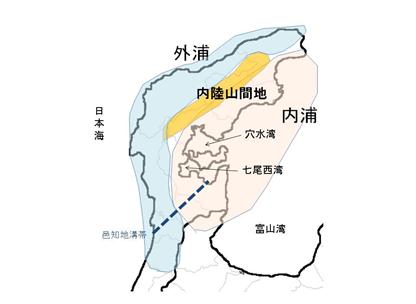
Diagram II-7-4: The three rural landscapes of Noto Peninsula
The Sotoura Landscape
The sea is rough on the Sotoura coast, with continuous wave-eroded steep cliffs and other unique landscapes formed through extreme natural phenomena including the scenic rock formations and steep cliffs of the Noto Kongo Coast and of the characteristic winter sea foam. In winter, seasonal winds from Siberia are strong, but since warm currents run along the coast, it is relatively warm and snowfall is limited, compared to the inland mountainous areas.
The landscapes of Sotoura such as the Shiroyone Senmaida Rice Terraces, the Agehama Style Salt Fields, and ‘Magaki’ bamboo fences are those that have been created by residents who have survived harsh natural environments over long periods of time. Even today, the Satoyama and Satoumi lifestyles centred on agriculture, forestry and fishing, maintain these unique landscapes, despite the difficulties of an aging and decreasing population.
There are many traditional homes in Noto with black tiled roofs and wooden siding walls, creating a unique homogenous landscape. The black tiles are also called ‘Noto tiles’, which are made from rice paddy clay and fired using firewood from the mountains. They have been produced in rural areas in Nanao City and Suzu City. Noto Tiles, with their beautiful black or silver-black glaze, are said to have excellent resistance to the cold. Wajima’s Kuroshima (formerly Monzen Town) and Unyu Town are famous as settlements where you can see a large group of houses built using Noto Tiles.
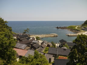
Photo: The view over a fishing village in Sotoura
Landscapes typical to Sotoura include the terraced rice fields (Senmaida) in Shiroyone Town (Wajima City), the agehama style salt fields on the Nie and Shimizu Coasts (Suzu City), and the ‘magaki’ bamboo fences in Osawa and Kamiosawa (Wajima City). At Shiroyone Senmaida, one can see over a 1000 small terraced rice paddies cut into the steep hillside along the coast facing Sotoura. And Noto is currently the only place where you can see agehama style salt field salt production. These scenes of salt production are the result of years of production which have been supported by the bounties of the satoyama and satoumi systems, utilizing small sections of flat land in the rough rocky landscape of Sotoura. The magaki bamboo fence landscapes are peculiar to the settlements facing Sotoura such as Osawa and Kamiosawa (part of Wajima City). At the same time as being a climatic landscape of distinctive structures built against the harsh seasonal winds, these fences can also be considered to be a satoyama / satoumi landscape where local resources are skilfully utilized.
In the Kuchinoto area south of Ouchi Lagoon (Hakui City), satoyama and satoumi landscapes different to the base of Noto Peninsula can be seen. Notable scenes include the dried ‘korogaki’ from Shika Town, and the rice terraces of Mikohara (Hakui City).
vii. Edited by Nanao City Historiography Committee (2003)
The Uchiura Landscape
The coastal area facing Toyama Bay on the eastern side of Noto Peninsula is called Uchiura. It is not as rough as Sotoura, and is relatively calm throughout the year. It is a good fishing spot due to the warm and cold currents that flow close to the shore. Along the coast, net fishing is popular and oyster farms and squid boats can be seen.
Nanao Bay, situated in the center of Uchiura, is an enclosed bay with land on three sides. Noto Island (part of Nanao City) is situated in the middle of the bay encircled by Noto Peninsula. The position of Noto Island divides Nanao Bay into three marine areas – the Northern Bay, the Western Bay and the Southern Bay. It is a calm area of sea even in the winter, and fishing is carried out year-round. The geography and landscapes of the coastline near Noto Island change regularly since the coast is made up of mainly diatomaceous earth with frequent erosion.
The inland areas facing Uchiura are thriving field cropping areas, with a calm climate, location away from the heavy snowfall areas, and gentle slopes. The area is known for its production of Noto Vegetables such as Nakajimana (a green leafy vegetable), Sawano burdock root, and tomatoes etc, along with dairy farming and wine grape production.
Along the coast, Suzu Shrine (Suzu City), Karashima Shrine (Nakajima Town, Nanao City) and Maruyama (Kabutohiko Shrine, Anamizu Town) have groves of virgin temperate broadleaf evergreen trees including the Japanese Bay tree, which are important parts of the landscape being near the sea, surrounded by rice fields and near fishing villages. These groves are considered to be sacred forests and cannot be pruned or cut down. Whilst being a sacred place for the community, they also serve as a nautical landmark and coastal reserves (believed to attract fish).
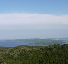
Photo: The Landscape of Uchiura
(looking over Nanao Bay and Noto Island)
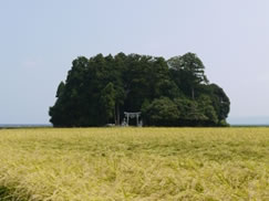
Photo: Shrine forest grove near the Nanao Bay Coast
The rough pattern of landscapes in Uchiura is the sea in the foreground, which could almost be called a ‘natural fish pond’ since it is calm and fishing can be carried out year-round; along with shrine forests and a scattering of settlements mostly situated near fishing ports along the coast; surrounded by rice fields, a distribution of diverse cropping areas including Noto Vegetables; and then in the background mountain areas, Japanese Cedar, the planted forests of Japanese Elk Horn Cedar, Konara Oak, and Red Pine (red soil) spread across the landscape; with an area of Japanese Zelkova growing on the wind-beaten coastline. Furthermore, floating in the bay are numerous islands such as Noto Island and Tsukue Island (both part of Nanao City). The air is clean, and on fine days, the Tateyama Mountain Range can be seen over Toyama Bay.
Typical landscapes of the Uchiura area are Anamizu Bay (Northern bay area of Nanao), the Western Bay area of Nanao, and Noto Nadaura on the Toyama Bay side.
Landscapes of the inland areas (foothill areas)
In the inland areas of Noto Peninsula (central low lying mountains and hilly areas), rainfall and snowfall is higher than the coastal areas, and the temperature is also lower. Due to low temperatures and high snowfall in the winter, there are stands of Beech trees and Mongolian Oaks near the summits of Mt Koshu (567m, summit part of Wajima City) and Mt Hodatsu (467m). Furthermore, there are few rivers, meaning that obtaining water was a big issue and it was not uncommon for the people to have to deal with water shortages. As a result, numerous reservoirs exist that were constructed by settlers and individuals, with the related maintenance/management and water distribution systems well established.
Homes in this area generally consist of a family home and a barn, plus a storehouse with earthen walls. Since the houses were often almost buried in snow during winter, it was common for the family home and the barn to be connected with a passageway. In addition, since farm work was often conducted inside, there was usually a large earthen floor room called a ‘niwa’ within the family home, which was used as a farm work room. Roofs were usually thatched (using mostly silver grass), but in the high economic growth period from around 1965, tiles became more common. Surrounding the residences are often Cedars and Japanese Elk Horn Cedars used for wind protection, as well as useful plants such as Japanese plums, persimmons and sakaki. It is common for slightly higher areas to be used for subsistence crops. Residences are often situated near water springs at the base of mountains, but in recent years, there have been cases of homes being built on the plains near main roads.
It is typical for rice paddies to be terraced, and situated on small raised areas of flat land either next to rivers or within valleys, often with a surrounding forest of cedar. Cuttings of Japanese Elk Horn Cedars were planted under the Cedars because of their high shade tolerance, and it was common to cultivate multi-storied forests. Prior to the fuel revolution (1955 onwards) there were Konara Oak forests and small-scale thatch plantations (grasslands for harvesting silver grass for roof thatching or for snow protection fences). The thatching grasses protecting the sides of rice paddies were also used as roof thatching. In Mitsui District (Wajima City) thatching grasses from rice paddies in derelict agricultural land are used for snow protection fences and a thatched house that is used as a community facility even today.
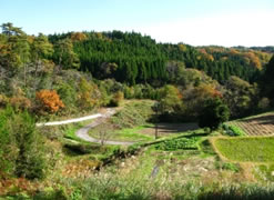
Photo: A Satoyama Landscape in the foothills (Hioki District, Suzu City)